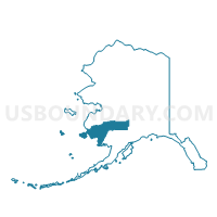
Chuathbaluk Precinct, Bethel Census Area, Alaska
About
Outline

Summary
| Unique Area Identifier | 523296 |
| Name | Chuathbaluk Precinct |
| County | Bethel Census Area |
| State | Alaska |
| Area (square miles) | 5.19 |
| Land Area (square miles) | 3.47 |
| Water Area (square miles) | 1.72 |
| % of Land Area | 66.81 |
| % of Water Area | 33.19 |
| Latitude of the Internal Point | 61.57553940 |
| Longtitude of the Internal Point | -159.24706980 |
Maps


Graphs
Select a template below for downloading or customizing gragh for Chuathbaluk Precinct, Bethel Census Area, Alaska